Bible Cartoon: Ruth 01 - Going to Moab - Scene 01 - Famine
Click on Add to cart button below shopping cart.
Purchased Bible Cartoons do not have watermarks. Links to Cartoons provided on email once purchase is completed.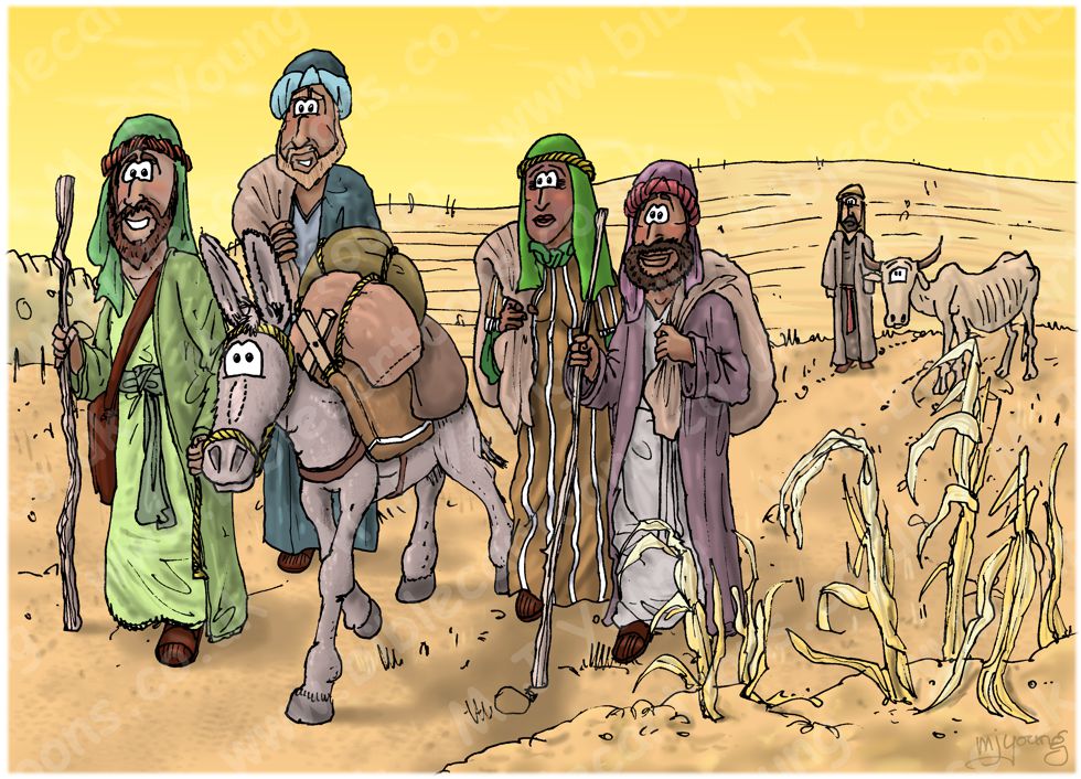


Bible Book: Ruth
Bible Book Code: 0800100101
Scene no: 1 of 6
Bible Reference & Cartoon Description
Ruth 1:1-2 (NLT)
1 In the days when the judges ruled in Israel, a severe famine came upon the land. So a man from Bethlehem in Judah left his home and went to live in the country of Moab, taking his wife and two sons with him. 2 The man’s name was Elimelech, and his wife was Naomi. Their two sons were Mahlon and Kilion. They were Ephrathites from Bethlehem in the land of Judah. And when they reached Moab, they settled there.
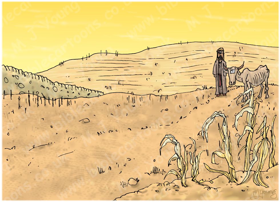
DRAWING NOTES:
TIME OF DAY:
Unspecified in Bible verses above. I have set the time in the early morning.
LIGHTING NOTES:
The sun (unseen, above & left) casts shadows to the right of figures & objects in this scene.
CHARACTERS PRESENT:
From left to right: Elimelech (the husband of Naomi) leading their donkey, Mahlon (son of Elimelech & Naomi), Naomi and Kilion (their other son).
In the background is a Hebrew farmer with a very thin, starving cow.
RESEARCH/ADDITIONAL NOTES:
I wanted the colours in this scene to reflect the harshness of a famine, so have used yellows & oranges, giving the impression of lifeless earth. The sky is also yellow, to continue the theme of a famine-stricken landscape. The background farmer & think cow are further visual clues to the famine.
This scene shows the family setting out from famine-stricken Israel, heading to Moab, which was a land South East of the Dead Sea.
Here’s the scene without the foreground figures:
Background of Ruth 01 – Going to Moab – Scene 01 – Famine
Click on the colour bar below to view/buy this Background:
Background of Ruth 01 – Going to Moab – Scene 01 – Famine
Where was Moab?
The kingdom of Moab was situated east of the Dead Sea, in what is now the country of Jordan. The lands’ boundaries have changed position somewhat over time, particularly the northern one, which could be represented by a line drawn East/West, several miles above the northern edge of the Dead Sea. The western edge of Moab was defined by the coast of the Dead Sea & the southern stretch of the Jordan River. Moab’s eastern boundary met the country of Ammon (home of the Ammonites) and the Arabian desert, from which it was separated by low, rolling hills. The southern border met with the country of Edom, in a line at the southern tip of the Dead Sea.
The Arnon river & gorge has always been an important boundary-line, separating the Moabites from the Amorites (Num. 21:13, 26; Deut. 3:8; Judges 11:18). After the Hebrew invasion of Canaan, the Arnon divided Moab from the tribes of Reuben and Gad (Deut. 3:12, 16). Actually Moab lay as much to the north of the Arnon as to the south! To the north, for example, were Aroer, Dibon, Medeba, and other Moabite towns. Even under Omri and Ahab, who held part of the Moabite territory, Israel did not hold sway farther south than Ataroth, about ten miles north of the Arnon.
The land of Moab was about 50 miles (80.5 Km) long and averaged about 30 miles (48.2 Km) wide. When viewed from the Dead Sea the land of Moab is a high tableland, with very steep cliffs leading down to the shoreline. The average high of the land above sea level is 3,000 ft (914 metres) & 4,300 ft (1310 metres) above the level of the Dead Sea.
Water has cut several impressive chasms or gorges in the rocks leading down to the Dead Sea, the principal one being the gorge of the river Arnon, which is about 1,700 ft. deep and 2 or more miles in width at the level of the tableland, but very narrow, with steep banks at the bottom. These gorges provide good protection from invading armies, having such steep sides that it would be very difficult for anyone to cross them, except in their upper courses near the desert where they become shallow.
Rain falls in winter only, but is usually sufficient to mature crops. The fountains and streams in the valleys and on the slopes near the Dead Sea are numerous, whereas the uplands/tableland are almost destitute of flowing water. The human inhabitants supply themselves by means of cisterns dug into the rocks, many of which are ancient.
About 45 place-names are known in the kingdom of Moab, but most of the towns are now ruins. The principal of these were: Ar (Numbers 21:15); Ataroth, Dibon, Jazer, Nimrah, Nebo (Numbers 32:3); Beth-peor (Deut. 3:29); Beth-diblaim, Bozrah, Kerioth (Jeremiah 48:22-24); Kir (Isaiah 15:1); Medeba, Elealeh, Zoar (Isaiah 15:2, 4-5); Kirheres (Isaiah 16:11); Sibmah (Joshua 13:19);
The limestone hills which form the almost treeless plateau are quite fertile. In the spring they are covered with grass; and the table-land itself produces grain.
Who were the Moabites?
We read of the beginning of both the Moabites & the Ammonites in Genesis 19:30-38. The Moabites were the descendants of Lot’s elder daughter, whilst the Ammonites being the descendants of his younger daughter. Lot was the nephew of Abram/Abraham, so the Hebrew people, the Moabites & Ammonites were thus related.
Deuteronomy 2:10-11 informs us that the Moabites displaced the previous occupants of their land, which they called the Emim.