Bible Cartoon: Matthew 02 - The Nativity SET 01 - Scene 15 - Nazareth in Galilee
Click on Add to cart button below shopping cart.
Purchased Bible Cartoons do not have watermarks. Links to Cartoons provided on email once purchase is completed.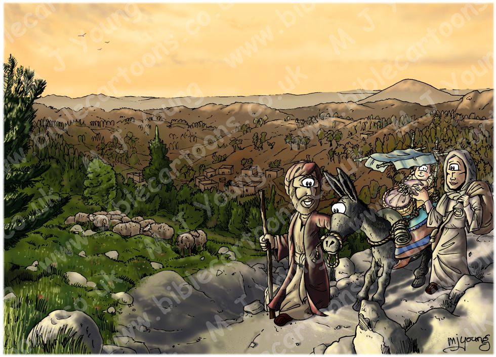


Bible Book: Matthew
Bible Book Code: 4000202201
Scene no: 15 of 15
Bible Reference & Cartoon Description
Matthew 2:22-23 (NLT)
22 But when he [Joseph] learned that the new ruler of Judea was Herod’s son Archelaus, he was afraid to go there. Then, after being warned in a dream, he left for the region of Galilee. 23 So the family went and lived in a town called Nazareth. This fulfilled what the prophets had said: “He will be called a Nazarene.”
DRAWING NOTES:
TIME OF DAY:
Late afternoon.
LIGHTING NOTES:
Day is drawing on & the sun is beginning to descend into the west, which is behind the viewer. Warm reds & oranges are contrasted with cooler greens & blues in the fore & mid grounds. Whilst the sun’s orange glow is contrasted with cooler grey-brown hues on the hills & mount Tabor.
The figures & pathway are highlighted in a yellow white glow coming from the sun.
CHARACTERS PRESENT:
Joseph leading their donkey. Mary is holding on to the cradle in which the infant Jesus has travelled from Egypt to Nazareth.
There are sheep on the hillsides.
RESEARCH/ADDITIONAL NOTES:
Notice that the infant Jesus is holding his mother Mary’s hand as they come to the end of their long trek from Egypt. Notice also that the donkey is “digging his heels in” a bit… perhaps he doesn’t like the steep descent down the rocky track?! Joseph is at the donkey’s head, reassuring & guiding.
I’ve used the same clothing & luggage for the travellers that I established in the previous picture.
Here’s the scene without the figures.
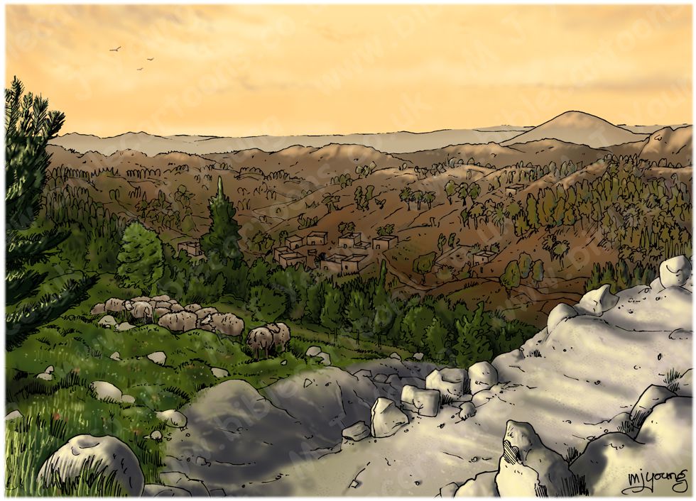
Background of Matthew 02 – The Nativity SET 01 – Scene 15 – Nazareth in Galilee
Click on the colour bar below to view/buy this Background:
Background of Matthew 02 – The Nativity SET 01 – Scene 15 – Nazareth in Galilee
Orientation: Nazareth is about 17.5 miles ( 28 km) from the Mediterranean sea at its closest.
It is about 15 miles ( 24 km) north east from Nazareth to the Sea of Galilee (aka Lake Tiberias or Lake Kinneret.)
The summit of Mount Tabor is only just over 5 miles ( 8 km) east from Nazareth.
The valley or plain of Meggido (part of the plain of Esdraelon, the great battle-field of Palestine) is just over 10.5 miles ( 17 km) in a south westerly direction from Nazareth.
Jerusalem is about 65 miles ( 105 km) almost due south of Nazareth.
To the south of the hills/mountains that surround the valley that Nazareth nestles inside is the valley of Jezreel, with the Carmel mountain range to the west & south west.
For further information regarding Nazareth see the Bible Cartoons Encyclopedia. [Add link]
Geography:
My research suggests there is some uncertainty about the exact location of the biblical village of Nazareth.
It seems to have been situated on the most southern of the ranges of lower Galilee, among the hills which are referred to as the south ridges of Lebanon, just before they sink down into the plain of Esdraelon (about 10 miles away (16 km)). A rocky gorge descends southward to a plain between two craggy hills.
Nazareth was situated on the southeast slope of a hollow pear shaped basin, which descends gradually from the elevated plateau 1500 feet above sea level and opens out through a steep winding way (the stem of the pear) into the plain of Esdraelon, 1000 feet lower. (source: Bible history.com)
In my picture you can see that the village/town of Nazareth is nestled in a rocky bowl, with hills all around. Joseph is Mary, Jesus & their trusty donkey down quite a steep rocky pathway, which leads into Nazareth.
In the background, behind the hills you can see Mount Tabor.
Geology:
According to geological maps Nazareth is situated on the Mount Scopus Group (Chalk, marl) ranges in thickness from 0–1,640 feet (0–500 metres), it averages about 984 ft (300 metres) thick.
It predominantly consists of biomicritic, bituminous, poorly-bedded, white foraminiferal chalk, which forms a characteristic landscape of soft hills. Hard calcareous chalks, biorudites and detrital sandy limestones usually occur at the base, and soft white marly chalks and shales terminate the sequence. Flint is abundant, and occurs as massive brecciated brown cliffs or thin continuous or nodular layers. (source: http://www.answersingenesis.org/articles/arj/v3/n1/geology-of-israel-2)
Points of note:
1) Hills of this chalk material form a “characteristic landscape of soft hills” rather than steep-sided cliff edged hills. This is why I have drawn rounded low hills in my cartoon.
2) “Flint is abundant”; this highly resistant, hard rock could be used as building material for homes & other houses. The buildings in my picture are made of flint nodules (lumps).
Some notes about Nazareth (aka Naz´areth, Naz´a-reth)
Nazareth is also known as En Nasira, Japhia, Mash-had, en-Nasirah, Nazerat, Nazareth of Galilee, Nazareth in Galilee, Yafti en Nasra (source: BiblePlaces.com)
In the time of Jesus Nazareth was probably a village or very small town. James F. Strange, an American archaeologist, notes: “Nazareth is not mentioned in ancient Jewish sources earlier than the third century AD. This likely reflects its lack of prominence both in Galilee and in Judaea.”34 Strange originally calculated the population of Nazareth at the time of Christ to be “roughly 1,600 to 2,000 people” but, in a subsequent publication, revised this figure down to “a maximum of about 480.” (source: E. Meyers & J. Strange, Archaeology, the Rabbis, & Early Christianity Nashville: Abingdon, 1981; Article “Nazareth” in the Anchor Bible Dictionary. New York: Doubleday, 1992.)
‘Nazareth is situated on the most southern of the ranges of lower Galilee, about ten miles from the plain of Esdraelon. “You cannot see from Nazareth the surrounding country, for Nazareth lies in a basin; but the moment you climb to the edge of this basin . . . what a view you have. Esdraelon lies before you, with its twenty battlefields—the scenes of Barak’s and of Gideon’s victories, of Saul’s and Josiah’s defeats. There is Naboth’s vineyard and the place of Jehu’s revenge upon Jezebel; there Shunem and the house of Elisha; there Carmel and the place of Elijah’s sacrifice. To the East the valley of Jordan, with the long range of Gilead; to the West the radiance of the Great Sea (The Mediterranean). . . . You can see thirty miles in three directions” (Smith, Hist. Geog., p. 432). Across the plain of Esdraelon emerged from the Samaritan hill the road from Jerusalem and Egypt.
Nazareth is not mentioned in the Old Testament. It was the home of Joseph and Mary (Luke 2:39); there the angel announced to Mary the birth of the Messiah (Luke 1:26-28), and there Joseph brought Mary and Jesus after the sojourn in Egypt (Matthew 2:19-23); there Jesus grew up to manhood (Luke 4:16) and taught in the synagogue (Matthew 13:54; Luke 4:16). His long and intimate association with this village made Him known as “Jesus of Nazareth” (Luke 18:37; John 1:45; etc.).
The disrepute in which Nazareth stood (John 1:46) has generally been attributed to the Galileans’ lack of culture and rude dialect; but Nathanael, who asked, “Can any good thing come out of Nazareth?” was himself a Galilean. It would seem probable that “good” must be taken in an ethical sense and that the people of Nazareth had a bad name among their neighbours for irreligion or some laxity of morals.’
(Source: The New Unger’s Bible Dictionary.)
Is it the valley of Jazreel, or the plain of Esdraelon?!
The Valley of Jezreel is often identified as comprising only the eastern end of the Plain of Esdraelon, the valley between between Mount Gilboa and the Hill of Moreh and Mount Tabor (see Mount Tabor). However, Jezreel is often used generally to refer to the entire flat and fertile plain stretching southeast from the coast north of Mount Carmel to the Jordan River at Beth-shan. This area is the boundary between Samaria to the south and Galilee to the north. (source: http://www.crivoice.org/phototour/pjezreel.html)