Research and notes on making the Maps of the Persian empire 500 B.C.
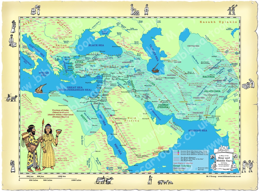 Map of Near and Middle East showing the Persian Empire
Link(s) to related Map(s)
Click blue bar below to see Map of the Persian empire, with purchase option:
View/Buy this map
Notes on the drawing of, and research for, this map
This map has taken a lot of time to research and draw, which is great in terms of knowledge acquired, not so good in terms of completing the Bible Cartoons themselves! However, I do hope that it will prove useful to someone. It was certainly fun for me to create!I discovered a lot about the region and history of the Near and Middle East whilst constructing this map.
Drawing Process
01) Firstly I had to determine the geographical extent of the Persian empire at its most expansive point, which was around 500 B.C. Then I was able to draw the outline map (with seas & land masses) as a basic blue & green vector outline drawing. I added the major sea names at this point.
I created the scale indicator at the bottom left of the map. That allowed me to create a measuring ruler which I used to triangulate the positions of rivers starts and ends, and city/town positions, in relation to fixed points on the coast.
02) Gradually I added the major rivers, starting with the Tigris and Euphrates rivers, in the middle of the map. I spent a long time investigating the shape and extent of the rivers and streams in all the countries on the map. I decided to name the major/longest ones (like the Danube, the Nile, the Indus) and some of the tributaries of these major rivers. I soon realised that there wouldn’t be enough room to provide a name them for them all!
03) I then added the red town spots and names. Again, it took many hours to research each and every city/town because I had to make sure that each one was inhabited at the time of the Persian empire. Most places have been inhabited for thousands of years, so I could be quite confident to include the locations I have on the map. I had to measure from known, fixed points on the map, triangulating a scaled distance, to accurately position the city/town dots.
04) I then added the mountain and hill icons. I learnt a lot about the various hill and mountain ranges in Egypt, Turkey, Saudi Arabia, Iran, Iraq, India & Central Asia. Particular challenges included accurately positioning the Hindu Kush, Pamir range and all the other mountain ranges on the eastern part of the map, since I knew very little about them! Equally, the accurate positioning of the mountains in the Saharan desert region (the south west of the map) was a challenge too, but, after much time and research, I eventually settled on the positions of all the ranges across the entire map.
05) Then I added the Mountain range names, over the major mountain regions. Again I realised that I was running out of space on the map to include all the mountain range names, especially the ones in Central Asia. At this point I thought about providing a Geographic map to viewers/customers, with the town spots and names, named rivers & named mountain ranges, without the Persian empire region marked on it.
06) It occurred to me that unless a viewer/customer was very familiar with the Near and Middle east regions, with all their many city/town names, rivers, mountains, etc then it would be difficult to refer to a particular feature for someone else to find on the map. By adding a grid overlay, using simple X and Y co-ordinates provided a way to refer to anywhere on the map. The X axis in horizontally across the map, while the Y axis is vertically from top to bottom. By using digits we can refer to somewhere between the lines of the grid. For example X 1.5 would be half way between the “1” & “2” lines on the X (horizontal axis), whilst Y 3.8 would be between the “3” & “4” lines (but much closer to the “4” line) on the Y (vertical axis).
This positioning system works best for locating small features (such as cities/towns), but is not so useful for larger features, such as long rivers, of mountain ranges. Nevertheless, it is still possible to refer to the North West (NW) quarter of the map, or the North East (NE), South West (SW) or South East (SE) quarters, and then refer to the XY co-ordinates of the name of a feature, in order to help someone to locate these larger features. For example, in the North West (NW) quarter of the map, at X 3.1/Y 1.7, is the named “Danube River”. The river flows from off the map (at X 0.3/Y0) to the Black Sea, at X4.2/Y1.2.
07) I realised that adding the most well-known or famous trade roads/routes might be useful, so set about researching those. Some were easier to establish than others!
I added the trade routes, linking various cities and towns. It was easy enough to determine where “The Royal Road” ran from (Sardis in modern Turkey) to Susa (in modern Iran), but I had to add some town spots and names (eg Gordian in Turkey (see grid X 4.6/Y 2.9), as I hadn’t included them in my first addition of town spots.
Adding “The King’s Highway” 7 “Via Maris/The Way of the Sea” was easy enough, but it took me a long time to try to determine where “The Incense Road” might have run from & to! This task was made harder by realising that there were several routes involved, and that these routes where related to tracks or pathways used over the past 6,000 years! I eventfully read enough material online to establish the major stop-over points, cities and towns on the various routes of “the Incense Road”. The 2 major overland routes (with 1 variant) are indicated on my map.
It should be notes that eventually the Arabian Sea and Red Sea were utilized to transport incense. Since this occurred around the 3rd century (some 200 years after the date of my Persian empire map (set at 500 BC)), obviously I have not included any reference to these maritime routes.
08) I added the turquoise coloured overlay, which shows the maximum geographical extent of the Persain empire, (around 500 B.C.). Then I researched the administrative divisions by which the empire was ruled at the time. I discovered that a satrapy was an administrative region or political district inside the Persian (Achaemenid) empire, whilst a satrap was the ruler or governor of that satrapy, who acted as a viceroy for the king, collecting taxes, keeping order, and judging local legal disputes.
I found a long, extensive document (on the Encyclopaedia Iranica website) which defined the term “satrapy”, and goes on the determine the geographical position and extent of each of these imperial administrative entities. From this I was able to label the Great, Major and Minor satrapies on my map. I am very grateful to have found this document, which aided me some much in this way!
[Source: https://www.iranicaonline.org/articles/achaemenid-satrapies/]
09) I added the coloured Persian figures in the bottom left hand corner and the black & white figures on the border of the map.
A note about the XY grid.
During the research and construction of this epic map I realised that it might be useful to provide several different versions of it. With everything included, the finished map is full to the brim of town spots and names, named rivers, named mountain ranges, trade routes, sea names, etc. I occurred to me that this level of detail could be quite overwhelming! And some viewers/customers might like a simplified version, without so much detailed nomenclature! It also occurred to me that adding a version(s) with a XY grid across it would aid in referring to any particular spot on the map. Therefore I have created a bundle of maps, with 3 decreasing levels of complexity, also included in the bundle are the same 3 maps with XY grids added.All versions of this map are shown at the bottom of this article.
Who ruled the Persian empire at its height of power?
The Persian (Achaemenid) Empire reached its largest territorial expanse around 480 to 500 BC during the reigns of Darius I and Xerxes I.Darius I
Darius I, also known as Darius the Great, reigned over the Achaemenid Persian Empire for 36 years, from 522 B.C. until his death in 486 B.C. Darius seized the throne in 522 B.C. after killing Gaumata (an alleged usurper who claimed to be Cambyses’s brother. Cambyses II was the son of and successor to Cyrus the Great. It was Cyrus the Great who united the Persian and Median tribes and conquered neighbouring kingdoms like Lydia and Babylon.Darius divided the vast Persian empire into provinces called satrapies (singular: satrapy), governed by loyal officials known as satraps. He standardized the economy by introducing a reliable coinage system featuring the Golden Daric, and improved communication and trade by building infrastructure, most notably the Royal Road (featured on my map) running from Sardis (in modern Turkey) to Susa (in modern Iran).
Darius the Great expanded the empire to its greatest size, stretching from Egypt and the Balkans to the Indus Valley.
Xerxes I
Xerxes I, also known as Xerxes the Great, who was the son of Darius I and Atossa (daughter of Cyrus the Great (reign: 559-530 BC)) replaced his father and ruled the Persian empire from 486 BC to 465 B.C. Xerxes I led the second major Persian invasion of Greece and suppressed revolts in Egypt and Babylonia.Esther married the Persian king Ahasuerus, who is widely identified by historians as Xerxes I. This union occurred in 478 B.C.
Artaxerxes I
Artaxerxes I reigned over the Persian Empire immediately after Xerxes I for 41 years, ruling from 465 to 424 B.C. Artaxerxes I (his mother was Amestris, the principal wife of Xerxes I) played a major supportive role in the biblical books of Ezra and Nehemiah. In the seventh year of his reign (Ezra chp 07), Artaxerxes granted Ezra the priest and scribe a royal decree allowing him to return to Jerusalem with a group of exiles, teaching the Law of God, and carrying gold, silver, and supplies for the temple. In the twentieth year of his reign (Nehemiah chp 02), Artaxerxes noticed his cupbearer, Nehemiah, looked sad over the ruined state of Jerusalem. The king gave Nehemiah safe passage, letters of protection, and timber to rebuild the defensive walls of Jerusalem.Conclusion
In conclusion, I do hope that you find this map (with its variants) useful, which is the whole point of spending so many days in constructing it!
Link to Maps
Click colour bar below to view/buy all 6 of the matching BC Maps in the bundle:
BC Maps: Near and Middle East (Persian empire) bundle
Return to BC Encylopaedia Index page